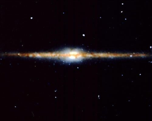
From its orbit around Earth, the Goddard Space Flight Center’s Cosmic Background Explorer (COBE) captured this edge-on view of our Milky Way galaxy in infrared light in 1990.
\n
Credit: NASA Goddard Space Flight Center
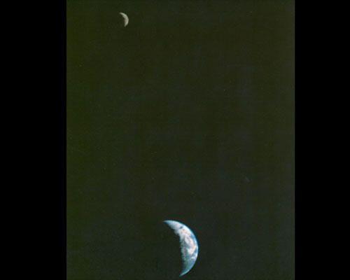
This picture of the Earth and Moon in a single frame, the first of its kind ever taken by a spacecraft, was recorded September 18, 1977, but NASA’s Voyager 1 when it was 7.25 million miles (11.66 million kilometers) from Earth.
\n
Credit: NASA
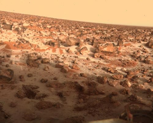
This color image shows a thin layer of water ice frost on the martian surface at Utopia Planitia. It was taken by Viking 2 Lander camera 2 on 18 May 1979, almost exactly one martian year (687 days) after the spacecraft imaged frost in the same spot.
\n\n
The layer is thought to be only a couple thousandths of a centimeter thick. It is speculated that dust particles in the atmosphere pick up tiny bits of water. When it gets cold enough for carbon dioxide to solidify, some of it attaches to the dust and ice and it falls to the surface. The view is looking towards the south southeast, the long boulder to the right is roughly one meter across.
\n\n
Image Credit: NASA

Global mosaic of 102 Viking 1 Orbiter images of Mars taken on orbit 1,334, 22 February 1980. The images are projected into point perspective, representing what a viewer would see from a spacecraft at an altitude of 2,500 km.
\n\n
At center is Valles Marineris, over 3000 km long and up to 8 km deep. Note the channels running up (north) from the central and eastern portions of Valles Marineris to the dark area, Acidalic Planitia, at upper right. At left are the three Tharsis volcanoes and to the south is ancient, heavily impacted terrain. (Viking 1 Orbiter, MG07S078-334SP)
\n\n
Credit: NASA
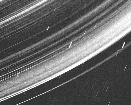
This dramatic Voyager 2 picture reveals a continuous distribution of small particles throughout the Uranus ring system. Voyager took this image while in the shadow of Uranus, at a distance of 236,000 kilometers (142,000 miles and a resolution of about 33 km (20 ml).
\n\n
This unique geometry — the highest phase angle at which Voyager imaged the rings — allows us to see lanes of fine dust particles not visible from other viewing angles. All the previously known rings are visible here, however, some of the brightest features in the image are bright dust lanes not previously seen.
\n\n
The combination of this unique geometry and a long, 96 second exposure allowed this spectacular observation, acquired through the clear filter of Voyager’s wide-angle camera. The long exposure produced a noticeable, non-uniform smear as well as streaks due to trailed stars.
\n\n
The Voyager project is managed for NASA by the Jet Propulsion Laboratory.
\n\n
Credit: JPL
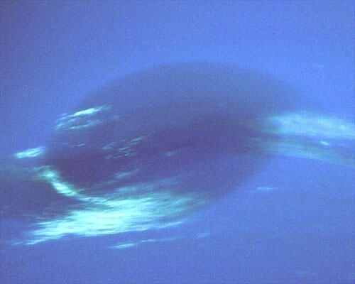
This photograph (1999) shows the last face-on view of the Great Dark Spot that Voyager will make with the narrow angle camera. The image was shuttered 45 hours before closest approach at a distance of 2.8 million kilometers (1.7 million miles). The smallest structures that can be seen are of an order of 50 kilometers (31 miles).
\n\n
The image shows feathery white clouds that overlie the boundary of the dark and light blue regions. The pinwheel (spiral) structure of both the dark boundary and the white cirrus suggest a storm system rotating counterclockwise. Periodic small scale patterns in the white cloud, possibly waves, are short lived and do not persist from one Neptunian rotation to the next.
\n\n
This color composite was made from the clear and green filters of the narrow-angle camera. The Voyager Mission is conducted by JPL for NASA’s Office of Space Science and Applications.
\n\n
Credit: JPL
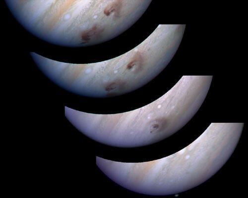
In July 1994, 21 chunks of comet Shoemaker-Levy 9, which had broken apart a year earlier, slammed into Jupiter. The Hubble telescope recorded this spectacular event.
\n\n
These images, beginning at lower right, chronicle the results of one such collision. Hubble began snapping pictures of the impact area just five minutes after the collision. Nothing can be seen. Less than two hours later, a plume of dark debris is visible [bull’s-eye pattern, image second from bottom]. Two impact sites are visible in the next picture, taken a few days later. The final snapshot shows three impact sites, the newest near the bull’s-eye-shaped region.
\n\n
Credit: R. Evans, J. Trauger, H. Hammel and the HST Comet Science Team and NASA
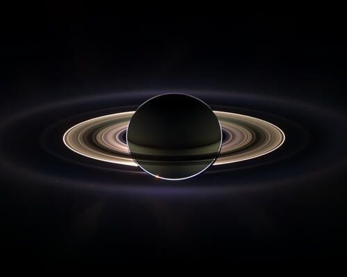
With giant Saturn hanging in the blackness and sheltering Cassini from the Sun’s blinding glare, the spacecraft viewed the rings as never before, revealing previously unknown faint rings and even glimpsing its home world.
\n\n
This marvelous panoramic view was created by combining a total of 165 images taken by the Cassini wide-angle camera over nearly three hours on Sept. 15, 2006. The full mosaic consists of three rows of nine wide-angle camera footprints; only a portion of the full mosaic is shown here. Color in the view was created by digitally compositing ultraviolet, infrared and clear filter images and was then adjusted to resemble natural color.
\n\n
The mosaic images were acquired as the spacecraft drifted in the darkness of Saturn’s shadow for about 12 hours, allowing a multitude of unique observations of the microscopic particles that comprise Saturn’s faint rings.
\n
Credit: NASA/JPL/Space Science Institute

This image (2004) shows a portion of a 1,700 km long and 65 km wide swath which was taken in south-north direction across the Grand Canyon of Mars (Valles Marineris) from two perspectives. It is the first image of this size that shows the surface of Mars in high resolution (12 metres per pixel), in color and in 3D.
\n\n
Credit: European Space AgencyDLR/FU Berlin (G. Neukum)

The heliosphere, in which the Sun and planets reside, is a large bubble inflated from the inside by the high-speed solar wind blowing out from the Sun.
\n\n
Pressure from the solar wind, along with pressure from the surrounding interstellar medium, determines the size and shape of the heliosphere. The heliosphere also is responsible for shielding out one-tenth of the galactic radiation coming in from the interstellar medium. IBEX will be the first spacecraft to observe the invisible interactions occurring at this boundary.
\n\n
The supersonic flow of solar wind abruptly slows at the termination shock, the innermost boundary of the solar system. The edge of the solar system is the heliopause. The bow shock pushes ahead through the interstellar medium as the heliosphere plows through the galaxy.
\n
Image Credit: NASA

This image of Hurricane Ivan, one of the strongest hurricanes on record, was taken Saturday from an altitude of about 230 miles by Astronaut Edward M. (Mike) Fincke, NASA ISS science officer and flight engineer, looking out the window of the International Space Station. At the time, Ivan was in the western Caribbean Sea and reported to have winds of 160 mph.
\n\n
Credit: NASA

Nine days before it entered orbit, Cassini spacecraft captured this exquisite natural color view of Saturn’s rings. The images that make up this composition were obtained from Cassini’s vantage point beneath the ring plane with the narrow angle camera on June 21, 2004, at a distance of 6.4 million kilometers (4 million miles) from Saturn. The image scale is 38 kilometers (23 miles) per pixel.
\n\n
The brightest part of the rings, curving from the upper right to the lower left in the image, is the B ring. Many bands throughout the B ring have a pronounced sandy color. Other color variations across the rings can be seen. Color variations in Saturn’s rings have previously been seen in Voyager and Hubble Space Telescope images. Cassini’s images show that color variations in the rings are more pronounced in this viewing geometry than they are when seen from Earth.
\n\n
Saturn’s rings are made primarily of water ice. Since pure water ice is white, it is believed that different colors in the rings reflect different amounts of contamination by other materials such as rock or carbon compounds. In conjunction with information from other Cassini instruments, Cassini images will help scientists determine the composition of different parts of Saturn’s ring system.
\n\n
Credit: NASA/JPL/Space Science Institute
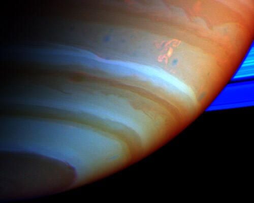
A large, bright and complex convective storm that appeared in Saturn’s southern hemisphere in mid-September 2004 was the key in solving a long-standing mystery about the ringed planet.
\n
Saturn’s atmosphere and its rings are shown here in a false color composite made from Cassini images taken in near infrared light through filters that sense different amounts of methane gas. Portions of the atmosphere with a large abundance of methane above the clouds are red, indicating clouds that are deep in the atmosphere. Grey indicates high clouds, and brown indicates clouds at intermediate altitudes. The rings are bright blue because there is no methane gas between the ring particles and the camera.
\n\n
The complex feature with arms and secondary extensions just above and to the right of center is called the Dragon Storm. It lies in a region of the southern hemisphere referred to as “storm alley” by imaging scientists because of the high level of storm activity observed there by Cassini in the last year.
\n\n
For more information about the Cassini-Huygens mission visit http://saturn.jpl.nasa.gov. For images visit the Cassini imaging team home page http://ciclops.org.
\n\n
Credit: NASA/JPL/Space Science Institute

This image shows NASA’s Phoenix Mars Lander’s solar panel and the lander’s robotic arm with a sample in the scoop. The image was taken by the lander’s Surface Stereo Imager looking west during Phoenix’s Sol 16 (June 10, 2008), or the 16th Martian day after landing. The image was taken just before the sample was delivered to the Optical Microscope. This view is a part of the “mission success” panorama that will show the whole landing site in color.
\n\n
The Phoenix Mission is led by the University of Arizona, Tucson, on behalf of NASA. Project management of the mission is by NASA’s Jet Propulsion Laboratory, Pasadena, Calif. Spacecraft development is by Lockheed Martin Space Systems, Denver.
\n\n
Credit: NASA/JPL-Caltech/University of Arizona/Texas A&M University
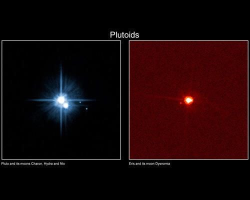
Pluto and Eris were the first worlds to be classified as Plutoids, a special class of dwarf planets that orbit our Sun in the icy region beyond the orbit of Neptune.
\n\n
The name plutoid was proposed by the members of the IAU Committee on Small Body Nomenclature (CSBN), accepted by the Board of Division III, by the IAU Working Group for Planetary System Nomenclature (WGPSN) and approved by the IAU Executive Committee at a June 2008 meeting in Oslo, Norway.
Plutoids are celestial bodies in orbit around the Sun at a semimajor axis greater than that of Neptune that have sufficient mass for their self-gravity to overcome rigid body forces so that they assume a hydrostatic equilibrium (near-spherical) shape, and that have not cleared the neighbourhood around their orbit. Satellites of plutoids are not plutoids themselves, even if they are massive enough that their shape is dictated by self-gravity. The two known and named plutoids are Pluto and Eris. It is expected that more plutoids will be named as science progresses and new discoveries are made.
\n
Credit: International Astronomical Union

This photo illustration shows selected moons of our solar system at their correct relative sizes to each other and to Earth.
\n\n
Pictured are Earth’s moon; Jupiter’s Callisto, Ganymede, Io and Europa; Saturn’s Iapetus, Enceladus, Titan, Rhea, Mimas, Dione and Tethys; Neptune’s Triton; Uranus’ Miranda, Titania and Oberon and Pluto’s Charon.
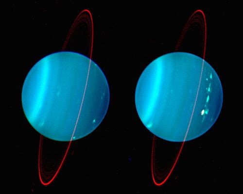
An infrared composite image of the two hemispheres of Uranus obtained with Keck adaptive optics.
\n\n
The component colors of blue, green, and red were obtained from images made at near infrared wavelengths of 1.26, 1.62, and 2.1 microns respectively. The images were obtained on July 11 and 12, 2004.
\n\n
The representative balance of these infrared images which were selected to display the vertical structure of atmospheric features gives a reddish tint to the rings, an artifact of the process.\n\nThe North pole is at 4 o’clock.
\n\n
Credit: Lawrence Sromovsky, University of Wisconsin-Madison/ W. M. Keck Observatory

This global view of the surface of Venus is centered at 180 degrees east longitude. Magellan synthetic aperture radar mosaics from the first cycle of Magellan mapping are mapped onto a computer-simulated globe to create this image.
\n\n
Data gaps are filled with Pioneer Venus Orbiter data, or a constant mid-range value. Simulated color is used to enhance small-scale structure. The simulated hues are based on color images recorded by the Soviet Venera 13 and 14 spacecraft.
\n\n
Credit: NASA/JPL

The spectacular image shown here is one of the first to be returned and shows a WAC image of the departing planet taken about 90 minutes after the spacecraft’s closest approach to Mercury. The bright crater just south of the center of the image is Kuiper, identified on images from the Mariner 10 mission in the 1970s. For most of the terrain east of Kuiper, toward the limb (edge) of the planet, the departing images are the first spacecraft views of that portion of Mercury’s surface.\n
See the Messenger Web site
\n\n
Credit: NASA/Johns Hopkins University Applied Physics Laboratory/Carnegie Institution of Washington
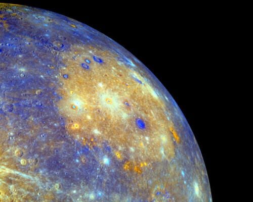
The sprawling Caloris basin on Mercury is one of the solar system’s largest impact basins. Created during the early history of the solar system by the impact of a large asteroid-sized body, the basin spans about 1,500 kilometers and is seen in yellowish hues in this enhanced color mosaic.
\n\n
The image data is from the January 14, 2008 flyby of the MESSENGER spacecraft, captured with the MDIS instrument. Orange splotches around the basin’s perimeter are now thought to be volcanic vents, new evidence that Mercury’s smooth plains are indeed lava flows. Other discoveries at Mercury by NASA’s MESSENGER mission include evidence that Mercury, like planet Earth, has a global magnetic field generated by a dynamo process in its large core, and that Mercury’s surface has contracted significantly as its core cooled.
\n\n
Credit: NASA

Selena Frye is a former Senior Editor for TechRepublic. Her background is in technical writing, editing, and research. I edit the Data Center, Linux and Open Source, Apple in the Enterprise, and IT Security blogs.


