The U.S. Geological Survey conducts research on natural resources, natural hazards, wildlife, water quality, and geography. The images and links to video in this gallery are only a selection of the many resources available at usgs.gov. All images in the gallery are in the public domain.
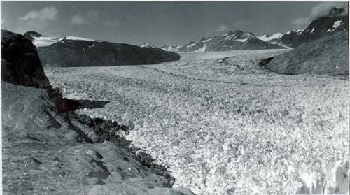
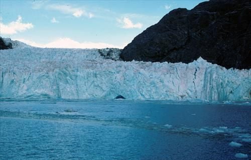
This August 1941 photograph is of Muir Glacier in Glacier Bay National Monument, Alaska. It shows the lower reaches of Muir Glacier, then a large, tidewater calving valley glacier and its tributary, Riggs Glacier. For nearly two centuries before 1941, Muir Glacier had been retreating. In places, a thickness of more than two-thirds of a mile of ice had been lost.
\n
Credit: U.S. Geological Survey
\nDepartment of the Interior/USGS
\nU.S. Geological Survey/photo courtesy National Snow and Ice Data Center and Glacier Bay National Park and Preserve Archive
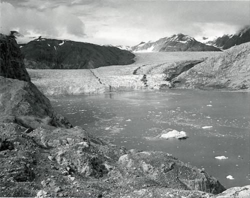
This August 1950 photo documents the significant changes that occurred during the 9 years between 1941 and 1950. Muir Glacier has retreated more than 2 miles, exposing Muir Inlet, and thinned 340 feet or more. However, it still is connected with tributary Riggs Glacier.
\n
Credit: U.S. Geological Survey
\nDepartment of the Interior/USGS
\nU.S. Geological Survey/photo courtesy National Snow and Ice Data Center and Glacier Bay National Park and Preserve Archive
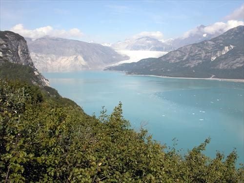
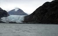
This August 2004 photo further documents the significant changes that have occurred during the 63 years since 1941, and during the 54 years since 1950. Muir Glacier has retreated out of the field of view and is now nearly 5 miles to the northwest. Riggs Glacier has retreated as much as 2000 ft and thinned by more than 800 feet. Note the dense vegetation that has developed. Also note the correlation between Muir Glacier’s 1941 thickness and the nearly horizontal line on the mountainside on the left side of the 2004 photograph. This line that indicates the past height of the glacier is called a trimline.
\n
Credit: U.S. Geological Survey
\nDepartment of the Interior/USGS
\nU.S. Geological Survey/photo by Bruce Molnia
This ship-deck-based August 1980 photograph of Muir Glacier and Muir Inlet, Glacier Bay National Park and Preserve, St. Elias Mountains, Alaska, shows the nearly 200-ft-high retreating tidewater end of Muir Glacier with part of its face capped by a few angular pinnacles of ice, called s\u00e9racs. Note the icebergs in the ship’s wake in the lower right side of the photograph. The location of Muir’s terminus is less than a mile from the landward end of Muir Inlet.
\n
Credit: U.S. Geological Survey
\nDepartment of the Interior/USGS
\nU.S. Geological Survey/photo by Bruce Molnia
This photo was taken in September 2003; in the 23 years between photographs, Muir Glacier has retreated more than a mile and ceased to have a tidewater terminus. Since 1980, Muir Glacier has thinned by more than 600 ft, permitting a view of a mountain with a summit elevation of greater than 4000 ft, located in the center of the photograph. A reexamination of the 1980 photograph shows that the summit of this mountain was visible but that it blended in with adjacent clouds.
\n
Credit: U.S. Geological Survey
\nDepartment of the Interior/USGS
\nU.S. Geological Survey/photo by Bruce Molnia
\n
Find these and other photos in the USGS Climate Change gallery.
Not a bad workplace!
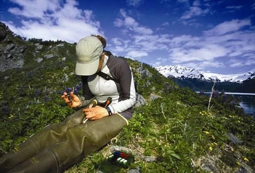
Alaska Unit master’s student Julie Morse bands a black oystercatcher.
\n
Credit: U.S. Geological Survey
\nDepartment of the Interior/USGS
\nU.S. Geological Survey/photo by Ron Niebrugge, U.S. Fish & Wildlife Service
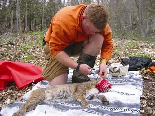
A Vermont Unit researcher outfits a captured bobcat with a lightweight GPS collar that will record its daily movements. The collar will provide information on bobcat home range size, habitat use, and movements.
\n
Credit: U.S. Geological Survey
\nDepartment of the Interior/USGS
\nU.S. Geological Survey/photo by Therese Donovan, U.S. Fish & Wildlife Service
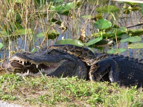
Yikes!
An American alligator and a Burmese python locked in a struggle to prevail in Everglades National Park. This python appears to be losing, but snakes in similar situations have apparently escaped unharmed, and in other situations, pythons have eaten alligators.
\n
Credit: U.S. Geological Survey
\nDepartment of the Interior/USGS
\nU.S. Geological Survey/photo by Lori Oberhofer, National Park Service
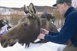
Scott Becker, a Wyoming Unit master’s student, attaches a radio collar to a moose cow as part of a study of moose movement, habitat use, and mortality rates in the area near Jackson Hole, Wyoming.
\n
Credit: U.S. Geological Survey
\nDepartment of the Interior/USGS
\nU.S. Geological Survey/photo by Wayne Hubert, U.S. Fish & Wildlife Service
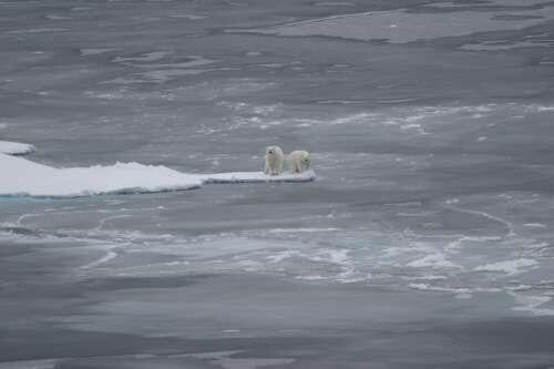
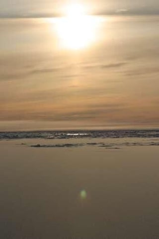
Lonely looking Polar Bears in a spit of Arctic ice.
\n
Credit: U.S. Geological Survey
\nDepartment of the Interior/USGS
\nU.S. Geological Survey/photo by Jessica K. Robertson
\n
Find these and other photos in the USGS Animals gallery.
.jpg?w=512)
A sea otter swims in Monterey Bay, California. USGS scientists study sea otters in efforts to help the threatened species continue to recover from near extinction.
\n
Credit: U.S. Geological Survey
\nDepartment of the Interior/USGS
\nU.S. Geological Survey/photo by Tania Larson
These next thumbnails link to short videos from motion-sensor activated cameras set up in the wild by USGS, offering fascinating, up-close glimpses of wildlife. Who doesn’t love bears? (From a safe distance, of course.)
\n
This Grizzly in Glacier National Park, Montana does not like having his privacy violated and goes directly for the camera. Check out the claws!
\n
Grizzly Bear Claws and Licks Camera
\n
Credit: Videographer J.Stetz / A.Macleod, USGS
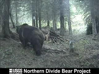
A grizzly bear climbs over barbed wire at a hair snag station near Glacier NP, Montana. DNA analysis of bear hair is used to identify individuals as part of study to determine the size of the bear population.
\n
\n
Credit: Videographer J.Stetz / A.Macleod, USGS
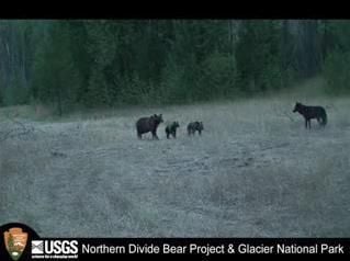
A grizzly bear with cubs chuffs and bluff charges a wolf. The wolf appears to be alone and, at times, postures as if it is playing.
\n
Grizzly Bear with Cubs Charges Wolf
\n
Credit: Videographer J.Stetz / A.Macleod, USGS
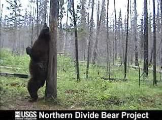
Black bear rubbing on a marking tree regularly used by other bears in Glacier NP, Montana. DNA fingerprinting of hair collected from natural rub trees is used to census the bear population.
\n
\n
Credit: Videographer J.Stetz / A.Macleod, USGS
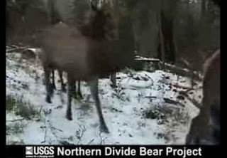
Elk walk past a bear rub tree in Glacier National Park; look out for the big antlers.
\n
Herd of Elk in Glacier National Park
\n
Credit: Videographer J.Stetz / A.Macleod, USGS

Selena Frye is a former Senior Editor for TechRepublic. Her background is in technical writing, editing, and research. I edit the Data Center, Linux and Open Source, Apple in the Enterprise, and IT Security blogs.


