A joint effort by a handful of agencies and a university has made it possible to track the progress of wildfires in the United States with maps updated several times a day and posted online for the public.\r\n\r\n
MODIS (Moderate Resolution Imaging Spectroradiometer) imaging devices mounted on two NASA satellites monitor the earth and can pinpoint a fire within a 500-meter distance.
\r\n\r\n
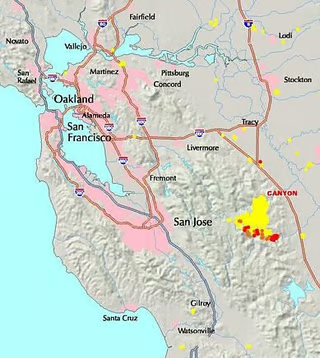
The instruments return data that is then turned into maps such as this one, which shows the location of past and actively burning fires near the San Francisco Bay Area. On July 9, a wildfire broke out in Stanislaus County, Calif., east of San Jose, damaging parts of Henry Coe State Park.
\r\n\r\n
Yellow on the map indicates an area that has burned at some point since Jan. 1; orange shows an actively burning area (in the last 24 hours); red shows an actively burning area (in the last 12 hours).
\r\n\r\n
NASA, the U.S. Forest Service, the University of Maryland and the National Interagency Fire Center all participate in the program.
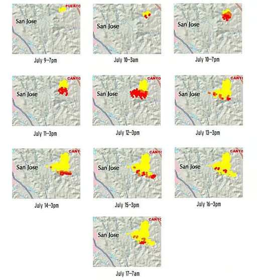
These images, taken from July 9 through July 17, show the development of a major wildfire that ripped through Stanislaus County, Calif.\r\n\r\n
At 7 p.m. on July 9, there is only a small yellow spot, indicating that a fire had burned in the area at some point during the calendar year. By 3 a.m. the next morning, however, several red spots appear, indicating active fires. The fires continue to grow over the next few days, peaking on July 12. The last image shown here, taken by the MODIS instruments at 7 a.m. on July 17, shows how extensive the burn area was.
\r\n\r\n
An update on the Forest Service’s Web site the evening of July 17 indicated the fire was approximately 85 percent contained but had scorched nearly 33,000 acres of land.
\r\n\r\n
Several government sites make it possible to get frequently updated information on active wildfires. The National Interagency Fire Center has updated news and information regarding the status of active wildfires, as well as statistics on past fires and suppression costs.
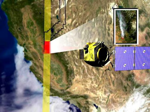
NASA uses the MODIS Rapid Response System as part of its SensorWeb project, in which sensors circling the earth act in a network, detecting fires or other events. When a MODIS sensor sees a fire, it alerts other sensors with the fire’s location so they can collect additional information in the area.\r\n\r\n
Steve Chien, of NASA’s Jet Propulsion Laboratory, explains how the networked satellites work in this short video.
Bill Detwiler is the Editor for Technical Content and Ecosystem at Celonis. He is the former Editor in Chief of TechRepublic and previous host of TechRepublic's Dynamic Developer podcast and Cracking Open, CNET and TechRepublic's popular online show. Previously, Bill was an IT manager in the social research and energy industries. He has bachelor's and master's degrees from the University of Louisville, where he has also lectured on computer crime and crime prevention.


